Price is: 1 person: $260 USD** 2 People+: $205 USD pp
Includes: Enduro Bike Rental, Bilingual Speaking Guide, Private Transport, Biking Gear, Lunch, Water and the Best Story of your life!
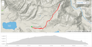
INCA AVALANCHE
This route follows the famous Inca Avalanche race course, which every April is the scene of a mad crowd of over 200 mountain bikers rampaging down the mountain in pursuit Acheter cialis en ligne france
of victory. More of a downhill trail it has a great mix of everything and will leave you with a permanent grin for weeks afterwards.
Distance: 8.88 miles/14.3 Km
Max. Elevation: 14135 ft./4,308m.
Elevation descent: 4970 ft./ 1514m.
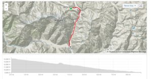 PATACANCHA Enduro
The scene of one of the highest Enduro bike rides in the world, this is one that will test your lungs and leave you loving the high alpine riding where you can choose your own free ride lines. A long, epic mountain bike trail this classic Enduro ride is located outside of Ollantaytambo in the Sacred Valley.
Distance: 17.3 miles/27.9 Km
Max. Elevation: 14552 ft./4,435m
Elevation descent: 5089 ft./ 1551m
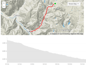
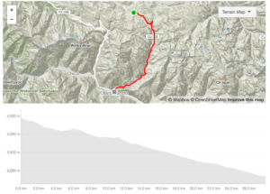 LARES Inca Trail
Lares is a fluid single track with a mixture of rocks, packed dirt, rock gardens, grass, small steps and some Inca stairs. Intermediate riders will find the trail fun and challenging. Pros will find it fast with natural jumps and hits. We will pass by Inca ruins throughout and ride to the final trail section down to Calca. Lares prevails as a local favorite due to the combination of fluidity and technical zones.
Distance: 11.24 miles/18.1 Km
Max. Elevation: 13847 ft./4,220m.
Elevation descent: 4206 ft./ 1282m.
LAMAY- MTB paradise
Distance: 8.5 miles/13.7 Km
Max. Elevation: 13744 ft./4,189m.
Elevation descent: 4068 ft./ 1239m.
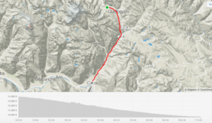
 HUCHUY QOSQO
Huchuy Qosqo: For those who want to add in some climbing on the ride, after reaching the pass you descend Inca trail passing through Inca ruins and riding some gnarly stair sections, eventually the trail kicks you out across the river from the town of Calca.
Distance: 13.1 miles/21.2 km
Max Elevation: 14163 ft/4317m
Elevation Descent: 4555ft/1388m